The ’Inimim Forest, named after the indigenous Nisenan word for “ponderosa pine,” may not be a household name, but the wildfire risk reduction and restoration treatments taking place within its boundaries address concerns discussed around many a nearby kitchen table and in the pages of California’s Forest and Wildfire Resilience Action Plan.
Forest-health work taking place among San Juan Ridge homes
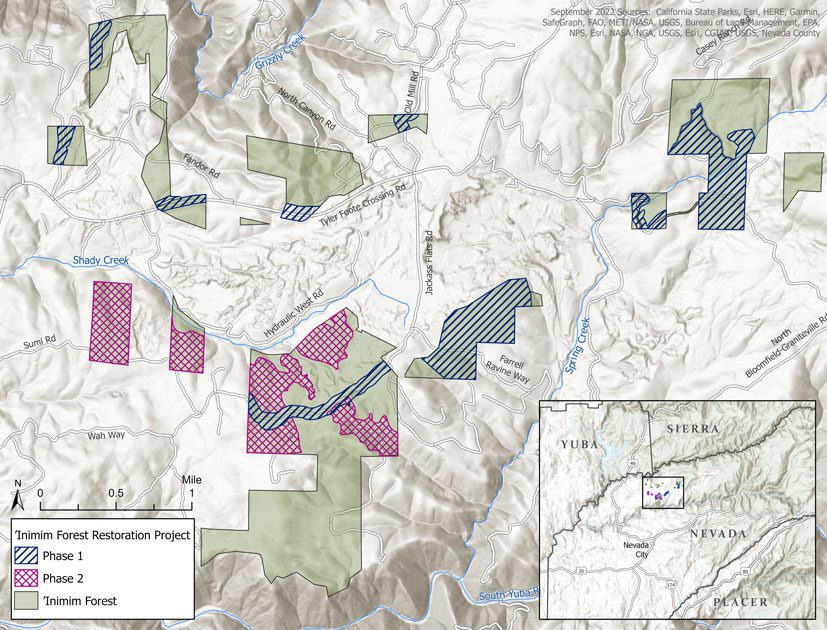
Funded by the Sierra Nevada Conservancy, CAL FIRE, and the Bureau of Land Management (BLM), the ’Inimim Forest Restoration Project will eventually reduce dense fuels on up to 1,200 acres of the ’Inimim Forest, a patchwork of ten different BLM parcels that total 2,000 acres. The Inimim Forest is located on the San Juan Ridge that divides the Middle and South Yuba rivers. It is surrounded by hundreds of dispersed homes and contains the historic North Columbia Schoolhouse Cultural Center that was built by miners in 1875.
It is also just a few miles from the historic gold rush town, and current county seat, of Nevada City.
“The ’Inimim Forest project on its own, when fully implemented, will help protect communities in the area should a fire come up one of the canyons. In addition, it offers a location for firefighters to safely fight a fire that comes from the north toward the community of Nevada City,” said Chris Friedel, executive director of the Yuba Watershed Institute (YWI), a nonprofit organization that partnered with the BLM back in 1990 to help manage the ’Inimim Forest.
Fire-risk reduction efforts factor in wildlife, ecological needs
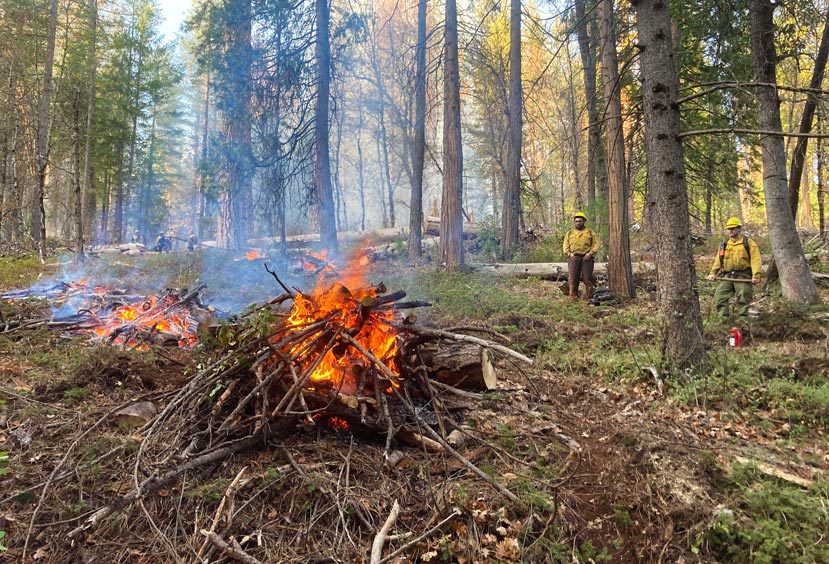
More than 500 acres have already been treated with hand-thinning, mastication, and pile burning in Phase 1 of the project that wrapped up earlier this year. Phase 2, which will be completed in the next few months, will bring the total to nearly 850 acres. The YWI is hoping the last 300-plus acres of fuels reduction will be finished within the next two years, however, it’s not rushing the work since it’s important to be extra meticulous with so many ecological factors to consider.
“What makes our organization unique is we are trying to implement these treatments in a way that is sensitive to wildlife and the other ecological aspects out there. What that means is we’ve done projects a little differently in terms of what treatments happen where and the level of detail that goes into determining what kind of treatments happen in each area,” stated Friedel. “It’s created a really interesting patchwork of different treatment types, from hand work, to machine work, to pile burning.”
One of the reasons the YWI is being extra cautious and detailed in its approach is the ’Inimim Forest is near the headwaters of two vital water sources that flow into each of the two rivers. It is also home to many wildlife species, including sensitive species, such as California spotted owl and northern goshawk.
“What we have also discovered over the years is there are some important wildfire corridors that are tying the South Yuba protected areas with wild areas of the Middle Yuba, and they go directly up and over and through the ’Inimim Forest. Having these protected lands, these mature forests, offer vital wildlife corridors protecting those two drainages,” added Friedel.
‘Inimim project part of larger South Yuba protection plan
While the restoration project is critical on its own, it is also part of a larger planned project called the South Yuba Rim Project. Led by Nevada County, in partnership with the YWI, this project will be a 17-mile-long fuel break that runs all the way from Bridgeport State Park to Malakoff Diggins State Park. According to Friedel, this fuel break, which includes the ’Inimim restoration efforts, will run the entire length of the populated areas of the San Juan Ridge.
Taking community wildfire protection one step further, the South Yuba Rim Project is part of CAL FIRE’s even larger effort to safeguard the towns of Nevada City and Grass Valley.
“The South Yuba Rim Project has been identified as a priority by CAL FIRE. They basically want to draw a (fuel-break) box around the communities of Grass Valley and Nevada City, and they’ve already drawn part of the western line of that box with the Ponderosa West Project,” said Friedel. “So, the South Yuba Rim Project would be the north line of the box helping to protect the cities of Grass Valley and Nevada City from fires coming from the north. And the ’Inimim Forest Restoration Project, already being partially implemented, is a key part of all of it.”
California’s Wildfire and Forest Resilience Action Plan—in action
When the Wildfire and Forest Resilience Task Force met in the Sierra Nevada on Sept. 22, the ’Inimim Forest was one of several projects attendees toured to see what resilience looks like on the ground. The ’Inimim project exemplifies how California’s Wildfire and Forest Resilience Action Plan works. Rather than imposing a top-down state plan, it is composed of regionally developed strategies, like CAL FIRE’s South Yuba Rim Project that contains the smaller ’Inimim Forest Restoration Project, that are informed by local knowledge and values.
On the San Juan Ridge, the need for fire safety coexists with care for wildlife and natural resources along with a desire to honor indigenous residents, and that’s exactly what this project is working to achieve.