
2021 Immediate Action
Wildfire & Forest Resilience Projects
SNC acted swiftly to award all $19 million of local assistance funding provided to the agency in the Early Action Wildfire and Forest Resilience Budget that state policymakers passed in April 2021.
In July 2021, we funded 15 shovel-ready projects to improve wildfire resilience on over 11 thousand acres of forestland and protect nearby communities and infrastructure. Most projects began in the summer of 2021.
Map Overview
Funded Projects
Projects are listed from north to south and correspond to the numbers on the map. Click on a project to learn more.
- Thompson Peak Initiative Bootsole Forest & Watershed Restoration Project (SNC #1305)
- Quincy Wildfire Protection Project (SNC #1317)
- Big Chico Creek Forest Resilience Project (SNC #1341)
- Concow Resilience Project: Implementation (SNC #1312)
- Mohawk Valley Wildfire Resilience Project (SNC #1319)
- Sierra Brooks—Smithneck Wildland Urban Interface Fuels Reduction Project (SNC #1314)
- Forbestown Forest Resilience Project (SNC #1343)
- Middle Fork American River Watershed Restoration Project (SNC #1337)
- Michigan Bluff Community Protection Project (SNC #1322)
- Twofer Pillikin Fuels Reduction Project (SNC #1325)
- West Fork Carson and Monitor Pass Project (SNC #1300)
- Trestle Mastication Project (SNC #1327)
- Tiger Creek Fuel Break Enhancement Project (SNC #1330)
- Rim Fire Plantation Thin/Biomass Treatment Project (SNC #1338)
- Wagner Ridge Fuel Break Project (SNC #1328)
Project Details
Thompson Peak Initiative Bootsole Forest & Watershed Restoration Project (SNC #1305)
| Cost | $3,671,725 |
|---|---|
| Grantee | Lassen Fire Safe Council, Inc. |
| Location | Lassen & Plumas Counties |
| Size | 3,770 acres |
| Timeline | August 2021–November 2024 |
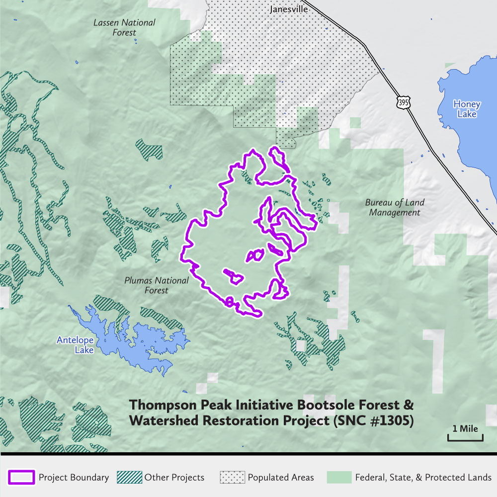
The Lassen Fire Safe Council Inc., in partnership with Plumas National Forest, will implement the 3,770-acre project located within the Plumas National Forest, southwest of the communities of Janesville and Milford and north of Antelope Lake. The purpose of the project is to reduce hazardous fuels, reduce risk to communities and the landscape from large, severe wildfires, restore forest health and resilience, improve wildlife habitat, and improve watershed condition.
The project is located in Lassen and Plumas Counties, and is a component of the large landscape-scale Thompson Peak Initiative covering approximately 92,713 acres. The project has been developed under the community-led Thompson Peak Initiative, with partners including Plumas National Forest, Susanville Indian Rancheria, California Department of Forestry and Fire Protection, Bureau of Land Management, Lassen County, Honey Lake Valley Resource Conservation District, and the Janesville and Milford Fire Protection Districts.
Quincy Wildfire Protection Project (SNC #1317)
| Cost | $433,280 |
|---|---|
| Grantee | Plumas County Fire Safe Council |
| Location | Plumas County |
| Size | 151 acres |
| Timeline | July 2021–Fall 2022 (Completed) |

The Plumas County Fire Safe Council will provide hazardous fuel reduction on 151 acres of private land southwest of Quincy in northeastern California. The project’s primary purpose is to reduce wildfire risk to the community of Quincy and its critical infrastructure, and to create a fire-resistant forest structure. The project is directly adjacent to residential neighborhoods, the Plumas District Hospital, and the SNC-funded Quincy Watershed Improvement Project, which includes the American Valley Community Services District’s primary water source for Quincy.
The project is included in the Plumas Communities Wildfire Protection Plan and addresses the Quincy Firewise Action Plan priority to “reduce vegetative material along roadway right of way.” The project area is within a Very High Fire Hazard Severity Zone in a Disadvantaged Community. Partners include the CHY Company, Plumas Corporation, and Plumas County Department of Public Works.
Big Chico Creek Forest Resilience Project (SNC #1341)
| Cost | $1,000,000 |
|---|---|
| Grantee | Butte County Fire Safe Council |
| Location | Butte County |
| Size | 451 acres |
| Timeline | August 2021–January 2025 |
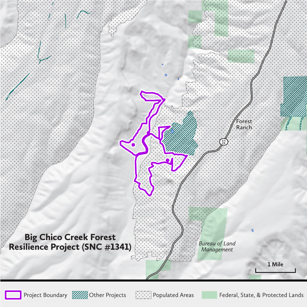
Butte County Fire Safe Council, in partnership with the Big Chico Creek Ecological Reserve and Grossman Family Trust, will reduce fuel loading and improve forest structure on 451 acres in northern Butte County adjacent to the community of Forest Ranch and close to the City of Chico and the community of Cohasset.
This project was planned with support of an SNC Watershed Improvement Program planning grant, is guided by the project’s forest management plan, and is supported by the local community wildfire protection plan. The treatments will reduce wildfire spread and intensity while retaining excellent habitat and water resource values. The project protects communities as well as the Big Chico Creek Ecological Reserve, an important educational resource for CSU, Chico, and the region.
Additional Information
Concow Resilience Project: Implementation (SNC #1312)
| Cost | $2,127,857 |
|---|---|
| Grantee | Butte County Resource Conservation District |
| Location | Butte County |
| Size | 784 acres |
| Timeline | Fall 2021–December 2024 |
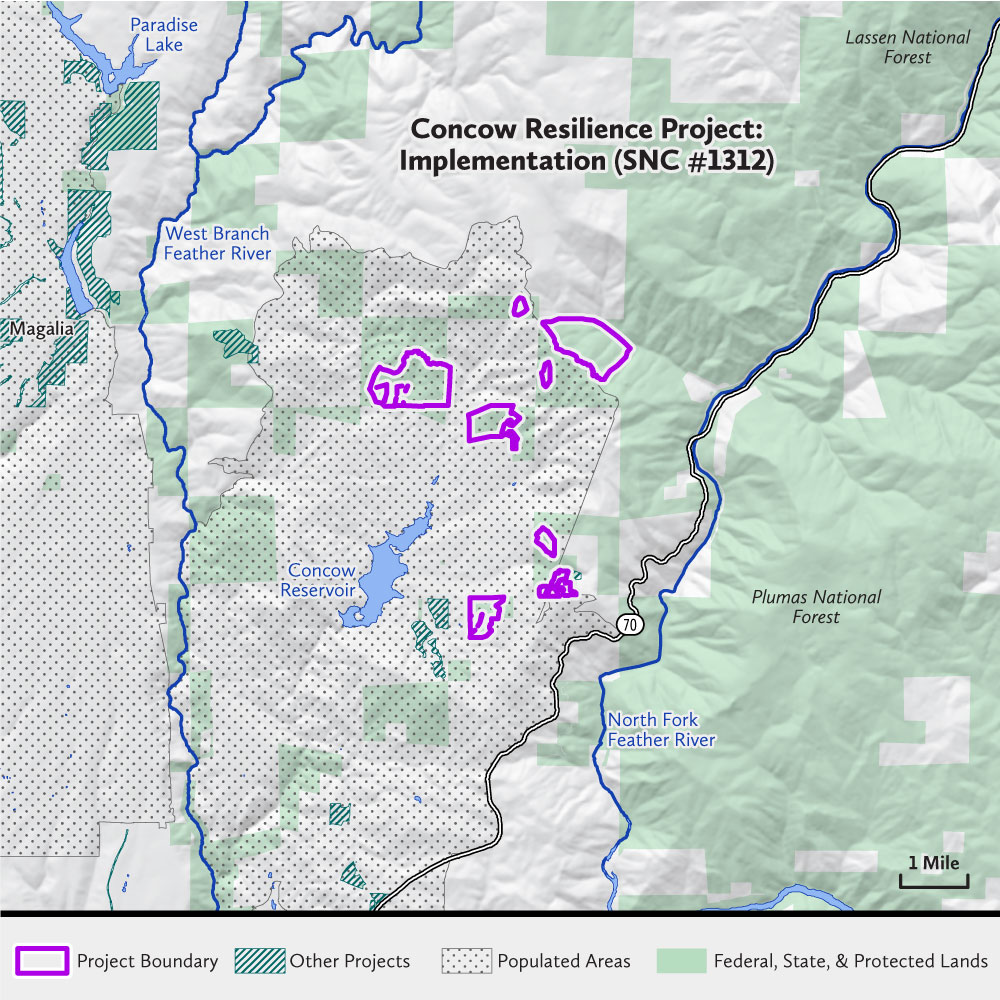
The Concow Resilience Project is in the Wildland Urban Interface of Butte County where dense conifer forest burned at high severity in the 2018 Camp Fire, resulting in almost 100 percent forest loss. The Butte County Resource Conservation District will implement the project on U.S. Forest Service lands that surround the rural community of Concow, 25 miles north of Oroville. The project will restore 784 acres of severely burned Sierra foothill forestland using methods that will make future fire behavior less severe and result in a climate-resilient, carbon-stable woodland. Project collaborators seek to actively manage the project area toward open, oak-dominated woodlands, conditions that are consistent with the pre-settlement landscape in addition to being drought- and fire-resilient.
The project is part of the Upper Feather River Integrated Regional Water Management Plan and is linked to the post-Camp Fire strategy of climate-resilient reforestation. It was developed with an SNC Watershed Improvement Program planning grant, in partnership with Plumas National Forest, the Pacific Southwest Research Station, American Forests, and Konkow Valley Cultural Preservation LLC.
Mohawk Valley Wildfire Resilience Project (SNC #1319)
| Cost | $1,022,082 |
|---|---|
| Grantee | Feather River Resource Conservation District |
| Location | Plumas County |
| Size | 727 acres |
| Timeline | February 2022–January 2025 |
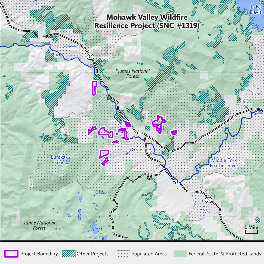
The Feather River Resource Conservation District, in partnership with the landowners, will lead a project to treat 762 acres of hazardous fuel loads on Plumas National Forest and Plumas Eureka Community Services District land. The project is located in Plumas County along the Middle Fork Feather River and the California Highway 70/89 corridor near the communities of Blairsden, Graeagle, Johnsville, and Plumas Pines. The primary purpose of the project is to reduce hazardous fuel loads in overstocked forest stands to create conditions that are more resilient to wildfire.
Treatment units were identified through a collaborative plan development process funded through an SNC Watershed Improvement Program grant under the Regional Forest and Fire Capacity Program. The project has been identified as a regional priority due to its location, current ecological condition, ability to impact water resources, wildlife, and wildfire resiliency as well as its proximity to critical infrastructure including water treatment centers.
Sierra Brooks—Smithneck Wildland Urban Interface Fuels Reduction Project (SNC #1314)
| Cost | $1,075,059 |
|---|---|
| Grantee | Sierra Valley Resource Conservation District |
| Location | Sierra County |
| Size | 723 acres |
| Timeline | August 2021–December 2024 |

The Sierra Valley Resource Conservation District will reduce heavy fuel loads on 723 acres of U.S. Forest Service and California Department of Fish and Wildlife lands adjacent to the Sierra Brooks Subdivision and one mile southeast of the community of Loyalton in Sierra County. Implementation of proposed treatments will benefit wildlife, including critical winter range for the Truckee-Loyalton deer herd, increase forest resilience and resistance to destructive wildfire, disease and insect infestation, and protect the community of, and water supply for, Sierra Brooks.
The long-term goal of the project is to return the landscape to a condition within the range of natural variability, allowing for prescribed underburns that will maintain healthy forest conditions. Treatments were identified as high priorities for fuels reduction in the Sierra County Community Wildfire Protection Plan, by the Sierraville Ranger District and the Sierra Brooks Firewise Community.
Additional Information
Forbestown Forest Resilience Project (SNC #1343)
| Cost | $500,000 |
|---|---|
| Grantee | Butte County Fire Safe Council |
| Location | Butte County |
| Size | 219 acres |
| Timeline | September 2021–January 2025 |
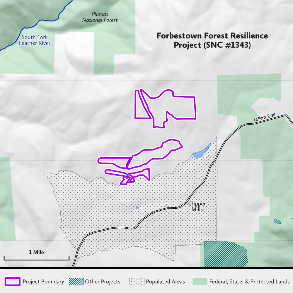
The Butte County Fire Safe Council will treat a minimum of 219 acres of private lands in Clipper Mills adjacent to the Merry Mountain Village subdivision in eastern Butte County, spanning a ridgetop that divides the South Fork Feather River and Yuba River watersheds. The project’s primary purpose is to prevent catastrophic wildfire by removing ladder fuels and thinning overstocked forests. Located within a CAL FIRE Very High Fire Hazard Severity Zone and targeting five properties, the project is a priority due to its proximity to Grizzly Creek and Merry Mountain Village subdivision.
The project is part of the CAL FIRE Butte Unit Community Wildfire Protection Plan for the Forbestown Ridge area and is included in the Butte County Local Hazard Mitigation Plan. The project was developed in consultation with multiple partners including CAL FIRE, U.S. Forest Service, Forbestown Ridge Fire Safe Council/Firewise USA, Mooretown Rancheria, American Forest Foundation, and Merry Mountain Village USA Firewise Community. Partnership funding will be provided by the U.S. Forest Service Steves Fund, CAL FIRE California Climate Investments, and the Western States Landscape Scale Restoration Program.
Additional Information
Middle Fork American River Watershed Restoration Project (SNC #1337)
| Cost | $1,000,000 |
|---|---|
| Grantee | Placer County Water Agency |
| Location | Placer County |
| Size | 494 acres |
| Timeline | August 2021–December 2023 |
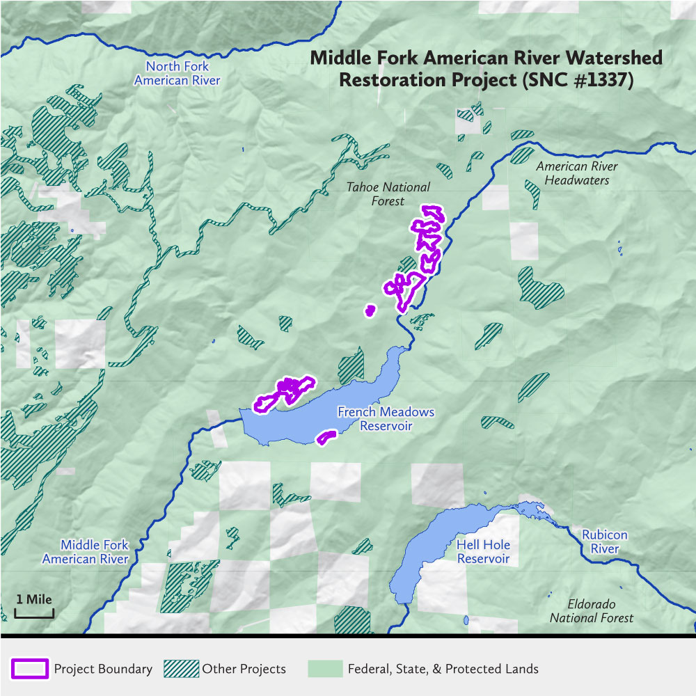
Placer County Water Agency is collaborating with Placer County and the Tahoe National Forest American River Ranger District through the French Meadows Partnership to implement 494 acres of forest treatments on American River Ranger District managed land adjacent to and upstream of the French Meadows Reservoir on the Middle Fork of the American River.
This project is part of the ongoing 28,000-acre French Meadows Restoration Project, supported by SNC, CAL FIRE, and United States Forest Service grants, among other funding. The outcome will be a landscape in an ecological condition that can support naturally occurring fires, while enhancing the region’s water supply and habitat for critical species by improving forest structure. The project will help protect critical water infrastructure and reduce the risk of catastrophic wildfire in the upper watershed. Partners on the French Meadows Project include the Tahoe National Forest, Placer County, Placer County Water Agency, The Nature Conservancy, and the American River Conservancy.
Additional Information
Michigan Bluff Community Protection Project (SNC #1322)
| Cost | $3,042,670 |
|---|---|
| Grantee | National Forest Foundation |
| Location | Placer County |
| Size | 1,266 acres |
| Timeline | September 2021–January 2025 |
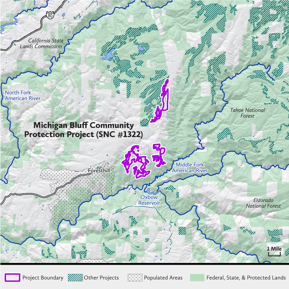
The National Forest Foundation, in partnership with the American River Ranger District of the Tahoe National Forest, will reduce hazardous fuel loads on1,266 acres of U.S. Forest Service land in Placer County. The Project immediately surrounds the rural community of Michigan Bluff and is about three miles east of the larger community of Foresthill. It is near the top of a ridge on the north side of the Middle Fork American River above Oxbow Reservoir and the Ralston Powerhouse, and will help protect a major tributary of Folsom Lake.
Due to fuels, terrain, and weather patterns, the project area is classified by the California Department of Forestry and Fire Protection (CAL FIRE) as a Very High Fire Hazard Severity Zone. This project is currently the top priority of the Tahoe National Forest.
Additional Information
Twofer Pillikin Fuels Reduction Project (SNC #1325)
| Cost | $1,255,225 |
|---|---|
| Grantee | Great Basin Institute |
| Location | El Dorado County |
| Size | 1,300 acres |
| Timeline | August 2021–January 2025 |
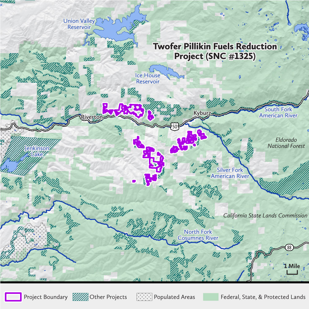
The Great Basin Institute, in partnership with the Eldorado National Forest and the Bonneville Foundation, will treat 1,300 acres of land managed by the Eldorado National Forest along Highway 50. The project area is located between Pollock Pines and Kyburz in El Dorado County, midway between Placerville and Echo Summit. The project will help protect the headwaters of the American River, and water and power infrastructure managed by the El Dorado Irrigation District and Sacramento Municipal Utility District, from catastrophic wildfire.
This effort is part of the Crystal Basin Focus Area, a large watershed encompassing Union Valley and Ice House Reservoirs, Alder Ridge, and a portion of the South Fork American River. The Crystal Basin Focus Area stems from the South Fork American River (SOFAR) Cohesive Strategy and is supported by a broad range of partners within the group.
West Fork Carson and Monitor Pass Project (SNC #1300)
| Cost | $1,401,520 |
|---|---|
| Grantee | National Forest Foundation |
| Location | Alpine County |
| Size | 494 acres |
| Timeline | July 2021–November 2024 |

The National Forest Foundation, in partnership with the Humboldt-Toiyabe National Forest, will implement 494 acres of hazardous fuel reduction and aspen restoration treatments in the Hope Valley and Pickett’s Junction area at the intersection of Highway 88 and 89 as well as along Highway 89 near Monitor Pass. The project area is in Alpine County, at the headwaters of the Carson River watershed.
This project is one component of a larger landscape strategy on the Humboldt-Toiyabe National Forest—Carson District and has been prioritized due to the extensive fuel loading, risk of loss/conversion of aspen stands, and proximity to high-value resources. Treatment outcomes will include reduced fuel loading, stand density, and conifer encroachment in aspen and meadow habitats, resulting in improved forest health and fire resiliency, improved hydrologic benefits, lower risk of high-intensity wildfire, and restored high-value aspen communities. Additionally, this project will increase local capacity and the pace and scale of forest treatments in Alpine County by supporting new partnerships and developing local workforce.
Additional Information
Trestle Mastication (SNC #1327)
| Cost | $370,300 |
|---|---|
| Grantee | National Wild Turkey Federation |
| Location | El Dorado County |
| Size | 317 acres |
| Timeline | N/A (Project cancelled due to Caldor Fire) |
The National Wild Turkey Federation partnered with the Placerville Ranger District of the El Dorado National Forest to treat 317 acres for fuels reduction in order to improve forest health and wildfire resiliency around the community of Grizzly Flats and nearby neighborhoods. Unfortunately, the Caldor Fire burned through the project area and town of Grizzly Flats before the project was implemented.
Tiger Creek Fuel Break Enhancement (SNC #1330)
| Cost | $220,200 |
|---|---|
| Grantee | Amador County Fire Safe Council |
| Location | Amador County |
| Size | 41 acres |
| Timeline | August 2021–June 2023 |
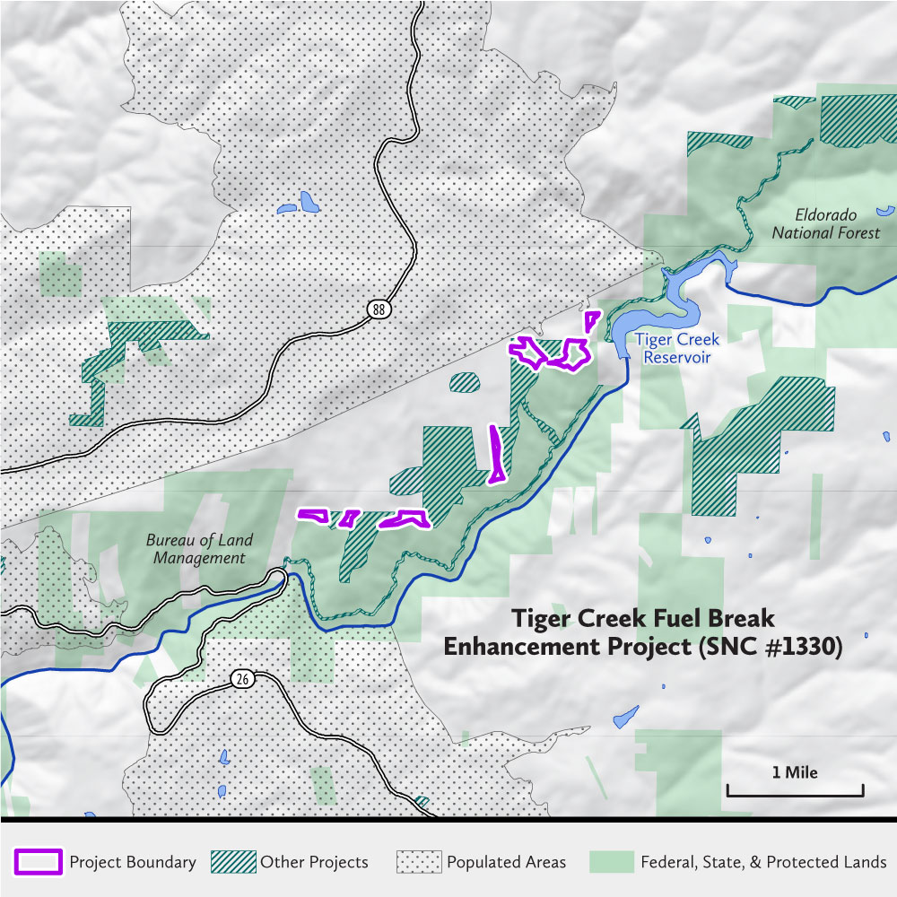
The Amador Fire Safe Council, in partnership with the Bureau of Land Management, will reduce fuels on 41 acres of Bureau of Land Management land in eastern Amador County near the communities of Pioneer and Buckhorn. These 41 acres of steep terrain will connect the major units of the Tiger Creek Fuel Break Project, a completed SNC Watershed Improvement Program fuel reduction project designed to protect mountain communities along Highway 88 and lands and infrastructure around Tiger Creek Reservoir.
The project lies entirely within the Mokelumne River Watershed and has direct impact on Tiger Creek Reservoir. This project enhances the effectiveness of a previous 220-acre Tiger Creek Fuel Break Project and is part of a larger, 3,000-acre fuel reduction strategy developed by the Amador Fuels Reduction Collaborative, which involves multiple partners including CAL FIRE, Bureau of Land Management, Eldorado National Forest, Sierra Pacific Industries, Pacific Gas & Electric, and other stakeholders in the region.
Additional Information
Rim Fire Plantation Thin/Biomass Treatment (SNC #1338)
| Cost | $1,368,000 |
|---|---|
| Grantee | Stanislaus National Forest |
| Location | Tuolumne County |
| Size | 684 acres |
| Timeline | August 2021–January 2024 |
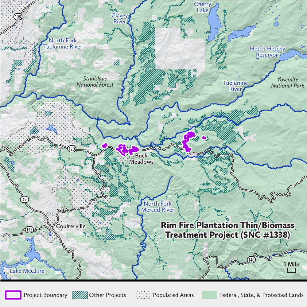
The Stanislaus National Forest will thin 684 acres of pine plantation in southern Tuolumne County near the communities of Groveland and Greely Hill. The areas of pine plantation selected for this project burned at low or moderate severity within the 2013 Rim Fire, leaving a high density of live trees and excessive amounts of ground and surface fuels. The planned treatments will improve forest structure and increase resilience to wildfire, drought, and pest infestations.
The treatment area is within the Wildland Urban Interface and will protect communities and public infrastructure. This project is an integral part of the overall Rim Fire recovery effort. The Stanislaus National Forest will partner closely with the Yosemite Stanislaus collaborative and the Mule Deer foundation to implement this project.
Additional Information
Wagner Ridge Fuel Break Project (SNC #1328)
| Cost | $608,982 |
|---|---|
| Grantee | Mariposa County Fire Safe Council |
| Location | Mariposa County |
| Size | 213 acres |
| Timeline | August 2021–Fall 2022 (Completed) |
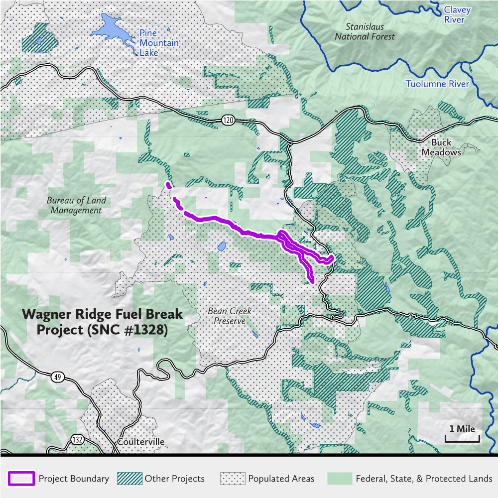
The Mariposa County Fire Safe Council, in partnership with the landowners, will treat 213 acres across Stanislaus National Forest and Bureau of Land Management lands along the northern boundary of Mariposa County, near the communities of Greeley Hill and Coulterville. The project will expand and widen a current fuel break that ties into the National Disaster Resiliency projects located on the Tuolumne County side of the ridgetop and lies on the watershed boundary between the Merced and Tuolumne River Watersheds.
Tying in with other ongoing work and existing fuel breaks, the project will ultimately result in a 400-foot fuel break along the entirety of the ridgetop. This will improve the abilities of land managers and firefighting agencies to contain and suppress wildfires and protect nearby communities as well as forest and watershed resources. Project planning was completed with support from an SNC Watershed Improvement Program planning grant. The Project is named in several strategic fuels plans and is a high priority project of the South West Interface Team collaborative.